From now until February 3rd, the Agency of Natural Resources is accepting public comment on a Draft Long Range Management Plan for the Worcester Range Management Unit that will shape how one of the largest blocks of State-owned land in Vermont is managed for decades to come.VMBA has identified several specific changes we would like to see to the Plan and is asking all those who enjoy riding on public land to review our recommendations and consider submitting public comments in support of these revisions.
The text below includes background on both the process and the lands in question, what is in the Plan, our concerns and recommendations, and, at the very bottom, draft text you can adapt in your own public comment, should you agree with our take on how to improve this critical document.
What is a Long-Range Management Plan (LRMP)?
On behalf of the State of Vermont, the Agency of Natural Resources (ANR) – through its Departments of Forests, Parks, and Recreation (FPR) and Fish and Wildlife (FWD) – manages state-owned land for a variety of purposes, ranging from the protection of important natural resources to public uses of land. ANR is the second largest landowner in the State, managing over 360,000 acres in 200 towns across Vermont.
The Agency of Natural Resources plans for the management of its state-owned lands through the development of long-range management plans (LRMP), aggregating parcels into Management Units. Planning processes are important for guiding the allocation of resources, such as where and what types of recreation occur, where and how timber is harvested, and the management of wildlife habitats. A comprehensive planning process is critical when such diverse interests are at stake (from https://fpr.vermont.gov/state_lands/lands-management-planning).
LRMPs are a complex undertaking, involving the collection and analysis of a great deal of information, including resource inventories, scientific assessments, and input from the public. Critically, LRMPs define the management activities that will be supported and pursued in a particular Management Unit for decades, as these plans are intended to be renewed every 20 years. Each year, a District Stewardship Team (DST) – which includes representatives from FPR, FWD, and the Department of Environmental Conservation (DEC) – creates an Annual Stewardship Plan that must align with the goals of the LRMP. In short, any activities that aren’t captured in the LRMP for a given Management Unit are extremely unlikely to happen in the lifetime of that plan.
Got it. So What is the Worcester Range Management Unit?
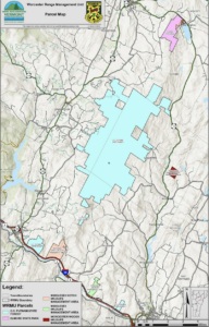
The Worcester Range Management Unit (WRMU) is located in north-central Vermont in the towns of Elmore, Worcester, Middlesex, Waterbury, and Stowe. The WRMU is made up of over 18,000 acres and includes five separate parcels: C.C. Putnam State Forest (SF), Elmore State Park (SP), Middlesex Notch Wildlife Management Area (WMA), Middlesex WMA, and Worcester Woods WMA. The WRMU encompasses most of the high-elevation lands along the spine of the Worcester Mountain Range, large areas of mid-elevation lands, and some low-elevation lands along the Winooski River Valley/Interstate-89 Corridor – including the Perry Hill Block and its iconic trail system in Waterbury. The State’s stated management goals for the WRMU include:
- Protecting the natural and cultural resources.
- Providing diverse recreational opportunities and trail systems.
- Producing a diverse array of forest products through sustainable management.
- Provide high-quality habitat for target and general plant and wildlife species.
In addition to Perry Hill, the WRMU features many other iconic recreation areas, including several hiking trails along and up to the Worcester Ridge (Stowe Pinnacle, Mt. Hunger, White Rock), Moss Glen Falls, Elmore State Park, and the Brownsville trail system in Stowe – home to some of the oldest original mountain bike trails in Vermont. In total, there are just shy of 43 miles of trails in the 18,773-acre Management unit, 10 miles (23%) of which are currently open to mountain bikes.
So what’s in the WRMU Draft LRMP, and what would it mean for mountain biking?
Firstly, you should review the draft LRMP for yourself! ANR has put together an excellent Story Map that walks through the Plan, and you can also peruse the full 285-page PDF if you’re looking for a little bedtime reading. As the sheer size of the document suggests, it contains a whole heck of a lot – there’s a reason these plans take, on average, 7 years to develop. We’ve done our best to distill what this draft Plan means for trail-based recreation and, specifically, mountain biking.
In terms of recreation, Nearly 80% of respondents in the public scoping considered recreation a ‘High” value, just shy of Fish and Wildlife Habitat (84.5%) and resource protection (85.2%), and far above the proportion who felt that Sustainable Forestry (49%) or economic benefit (28.9%) were high priorities. A stated goal for the WRMU is to “provide diverse recreational opportunities and trail systems where appropriate and compatible with other goals.” The proposed general strategies in pursuit of this goal include maintaining and improving existing public access, maintaining existing trail systems, and “exploring opportunities to expand recreation,” explicitly referencing VMBA and our WATA and STP Chapters as partners in this effort. This Draft includes no plans for additional trails within any of the Recreation Areas, though additional trails can be considered by interested partners submitting proposals to the Barre District Stewardship Team.
“Mechanized activity” (mountain biking) was identified as the 2nd most popular current use in the WMRU among public scoping survey respondents (48%) behind hiking (85%), despite the fact that less than a quarter of the current trails are open to bikes. Over 40% of respondents said there were too few ‘mechanized (bicycle) recreational Trails’, more than any other listed resource. The second greatest shortfall identified in the public scoping was too few universally accessible trails (35%). Both these needs exceed the proportion of respondents who felt there was too little parking (31.6%), managed wildlife habitat (30%), or dispersed recreation opportunities (14.3%). Less than 13% of respondents considered there to be a “high” degree of conflict between recreation and wildlife.
It is a stated goal of the plan to restore mechanized (bicycle) access to the Brownsville trail network, which includes the Iberno Trail – one of the first mountain bike trails built in Stowe. These trails had long been used for mountain biking before the acquisition of the parcel by FPR in 2019, though they are presently open only for pedestrian use. The draft Plan calls for the total trail mileage at Brownsville to be permanently capped at 5 miles, aligned with the parcel’s historic trail mileage. At Perry Hill, additional trails will be considered if they provide connectivity to adjoining parcels, solve documented issues with user dispersion and/or correct impacts or add to trail network sustainability, avoid significant ecological impact to sensitive features identified in the ecological assessment, pending ecological assessments of potential corridors of connectivity and DST review and approval.
What is VMBA’s perspective on the WRMU LRMP?
Clearly, this is an extraordinarily well-researched document that includes ample study and data collection. It was encouraging to see how much mountain biking was valued as a use of public land and the degree to which additional ‘mechanized’ access was desired by the public. We also greatly appreciate the degree of public engagement that has been sought, both in the initial scoping and at this phase in response to the draft management plan.
Firstly, the things we’re really excited to see:
- This draft Plan would restore bike access to the Brownsville trail network, pending the upgrading of the trails to modern sustainability standards, and establish Stowe Trails Partnership as the primary stewardship partner. This will not only provide folks another fantastic riding option in the Stowe area, but also help ensure these trails are upgraded and maintained to a high standard.
- As drafted, this LRMP would be the first to incorporate winter fat bike access on State land. This was no small feat, and stems from the hard work of both the Department of Forest, Parks & Recreation and Waterbury Area Trail Alliance in designing and running a successful pilot winter-use program.
Despite these highlights and the general thoughtfulness with which this Plan has been developed, we do have a number of concerns:
- Despite the apparent public desire for increased recreational opportunities, language pertaining to recreation management actions is almost entirely passive or noncommittal – ‘consider’, evaluate’, ‘explore – whereas management actions for wildlife habitat management, resource protection, and timber harvesting are generally active and specific – ‘protect’, ‘prevent’, ‘enhance.’
- With respect to recreation, it is unclear to what degree, if any, the public scoping that took place in 2020 has been incorporated into the draft Plan. Despite the cited scoping data and the clear public desire for greater mechanized access to the WRMU, the draft plan contains no plans for additional trails – even within the Recreation Areas like Perry Hill that are “managed primarily for recreational value.”
- Accessible recreational access is entirely overlooked and absent from the draft plan. The Term ‘accessible’ pertaining to recreation is found only 3 times in the entire 285-page document – once in reference to the early development of what is now Elmore State Park as a ‘recreation place accessible by car,’ once regarding the need for continued work to create a more accessible and sustainable treadway for the quarter-mile Moss Glen Falls Trail, and in the Public Scoping Summary (in the appendix), in which 35% of respondents said there were too few Universally Accessible Trails, second only behind those who felt there were too few mechanized trails. ‘Accessibility’ is wholly absent.
- It is absolutely essential that real recreational goals are embedded as management goals in this Plan. Proposals for trail projects on the lands in this Management Unit will be judged against the management goals in this LRMP for the next 20 years, at least. Even if they are endorsed by the District Stewardship Team, projects that aren’t clearly compatible with will require a formal amendment to the Plan – a very challenging hurdle that could likely delay such efforts to the next LRMP.
- These concerns are exacerbated by the fact that the draft Plan extends the amount of land categorized for ‘Highly Sensitive Management’ to over 50% of the 18,700+ acres, wherein the #1 priority is preservation due to “uncommon or outstanding biological, ecological, geological, scenic, cultural, or historical significance.” The development of new recreational access in these areas would be extremely challenging.
What would VMBA like to see changed in this Draft Management Plan?
There are a series of specific changes we are suggesting, specifically:
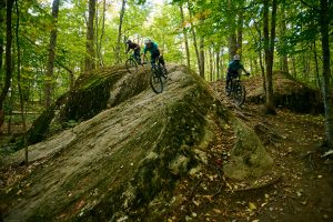
Waterbury Area Trails Alliance
Photo By Bear Cieri
- Commit to expanding mechanized access in the LRMP:
-
-
- Actively seek proposals to add trails within the Recreation Areas (Perry Hill and Stowe Pinnacle), rather than simply “consider” additional trails under the specified conditions. We are happy to meet the stated requirements but would appreciate having a shared goal with ANR to expand trail opportunities. Ideally, this LRMP would have a discrete target in terms of additional trail new mileage.
- Explicitly consider proposals for non-motorized trail development in Highly Sensitive Management areas, which make up over half (52%) of the WMRU, provided these projects maintain the “outstanding biological, ecological, geological, scenic, cultural, or historical significance” of the area. Allowing people to sustainably access these zones is integral to their long-term conservation from development. The presence of social trails not only underscores the public’s desire to recreate in these areas but also promotes unsafe and environmentally damaging access.
-
- Address the need for more accessible recreation:
-
- Currently, of the 43 miles of trail in the WMRU, only the 0.25-mile Moss Glen Falls trail is considered accessible to those with serious physical disabilities. While most of the terrain in the WMRU makes true Universal Access Trails extremely difficult to achieve, trails built to adaptive mountain bike standards could be possible across much of the Management Unit. Some level of accessibility should be considered, specifically for the proposed sustainable loop trail system at Stowe Pinnacle.
- Much of the existing Perry Hill trail system could be retrofitted to accommodate aMTBs without altering existing trail characteristics through the removal of impediments such as narrow bridges, pinch points, and tight corners. These upgrades would also not compromise environmental sustainability and, in many cases, actually reduce erosion resulting from water and trail use.
- New access for aMTBs (and mechanized use) should be promoted elsewhere in the Unit, consistent with the recommendation above to consider proposals for non-motorized trail development. These trails should be, by design, optimized for adaptive mountain bikes and would open up access to areas of the Worcesters previously only able-bodied visitors could enjoy
And here’s where you can help! Public comment on the draft LRMP is open through February 2, 2024. The Agency reviews each and every comment it receives, and the more voices it hears calling for the changes above, the more likely we are to see them realized in the final LRMP. Please take a moment to submit your comment by email, phone, snail mail, or perhaps easiest, through the simple WRMU Draft Management Plan Public Comment Form. As VMBA, we’ve submitted this letter as public comment, but here’s a template you can use or adapt based on your own perspective on the draft Plan:
To the Agency of Natural Resources,
Firstly, thank you for the immense amount of time and energy that your staff has invested into the Draft Long Range Management Plan for the Worcester Range Management Unit. The document provides a wealth of information and clearly aims to balance many different uses in charting out the next two decades for this incredibly valuable piece of Vermont.
Specifically, I strongly support the planned reopening of the Brownsville trail system to mountain bikes, which will provide an additional wheeled recreation option in an area where demand has grown dramatically the past few years. I also am strongly in favor of the permanent establishment of winter fat biking at Perry Hill, which provides a great winter use option in response to the growing fat bike community – both in Vermont and those who travel here to ride.
While the Plan is commendable on many fronts, it does fall short in two areas that were clearly articulated as compelling needs in the public scoping that preceded the report and is included in its Appendix. Firstly, despite mountain biking being the 2nd most popular form of recreational use in the WRMU, and the fact that ‘mechanized’ trails were considered insufficient by more public scoping respondents than any other resource, the Plan calls for no increase in access for mountain biking – nor for any new trails. This seems to run contrary to the stated management goal of “Providing diverse recreational opportunities and trail systems” and certainly in contrast with public sentiment.
The final Plan should actively seek proposals to add trails within the Recreation Areas (Perry Hill and Stowe Pinnacle), rather than simply “consider” additional trails under the specified conditions and include a discrete target in terms of additional trail new mileage or new miles open to mechanized access. It also seems critical that proposals for non-motorized trails in Highly Sensitive Management areas, which now make up over half of the WMRU, provided these projects meet the environmental preservation requirements. Allowing people to sustainably access these zones is essential to our long-term appreciation for their conservation.
Additionally, the final Plan should directly address the need for more accessible recreation. Only 0.25 miles of trails in the WRMU are accessible to those with serious physical disabilities. Some level of accessibility should be considered, specifically, for the proposed sustainable loop trail system at Stowe Pinnacle. Upgrades to existing ‘mechanized’ trails could make them accessible to adaptive mountain bikes without noticeably affecting their character, and new access for aMTBs elsewhere in the WRMU could open up access to areas of the Worcesters previously only able-bodied visitors could enjoy.
Thank you again for your hard work in developing this plan, and for your thoughtfully considering public comments on the long-term management of our public lands.
Sincerely,
YOUR NAME
Thank you for your help in securing expanded and improved public access to lands like those in the Worcester Range Management Unit. Your voice will absolutely make a difference.